A hike to the summit of Gray Butte makes for a memorable Father’s Day outing
Published 4:30 am Friday, June 24, 2022

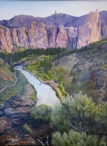
- A group of motorcyclists enjoy the view from the top of Gray Butte on Sunday.
From the summit of Gray Butte, the Crooked River National Grassland stretched westward for miles toward cloud-shrouded Cascade peaks. To the east, the city of Prineville lay tucked below the tree-covered Ochoco Mountains.
Trending
Gray Butte does not make any lists of the best hikes in Central Oregon, but on Father’s Day it offered an opportunity to try something new and reach the top of a prominent peak with the entire family.
Until Sunday, Gray Butte had always been a mountain biking destination for me. The Gray Butte Trail offers dynamic hillside singletrack that connects to scenic trails in Smith Rock State Park.
But this was to be solely a hiking outing, and my wife, 14-year-old son and 12-year-old daughter were all determined to reach the summit.
Trending
The drive from Bend to Skull Hollow Campground just southeast of Gray Butte was about 45 minutes. The campground is a launching point for mountain bikers, horseback riders, hikers and trail runners. We continued along bumpy, rocky Forest Service roads to a small parking area just south of the butte. (Hikers can also start from Skull Hollow for a longer trek, or approach the climb from the north via the Gray Butte Trailhead.)
The hike started out easily enough, under cloudy skies in comfortable 60-degree weather. (With high temperatures expected in the coming days, this exposed hike will be best done early in the morning or later in the evening when conditions are cooler.)
After about a half mile, we reached an area known as “the saddle,” where the Cole Loop Trail connects with the Gray Butte Trail and the dirt road to the summit. It’s a place I had been numerous times on my mountain bike, always staying on the singletrack. This time we would take the rocky dirt road to the summit.
The climb got increasingly steep as the top grew closer. Views to the east toward the Ochocos opened up and yellow wildflowers were in full bloom.
The slow, steady climb gave us time to talk about summer plans, allowing some bonding time and a break from the daily routine of work, school and sports activities.
Two dedicated runners passed us going up and then again going down, getting some massive elevation gain into their workouts. Four motorcyclists also passed us. I talked to them at the summit and they said they had ridden dirt roads from east of Bend all the way to Gray Butte.
When we finally reached the summit after a 2-mile climb up the road, we took the time to snap photos and eat some energy bars. There was only one other hiking couple and the group of motorcyclists.
Gray Butte is not crowded with hikers, unlike nearby Smith Rock State Park. Misery Ridge is a beautiful hike, but I’m sure we would have had to share it with dozens if not hundreds of others on Sunday.
Extremely motivated hikers looking for a long, vertical challenge can start from Smith Rock State Park, and take either the Summit Trail or Burma Road to the saddle, then the road to the summit of Gray Butte.
But we were content with our 4-mile hike, which included 1,800 feet of elevation gain and required about two hours. We were tired but not completely exhausted, so I knew it was just the right amount of hiking for the family.
For hikers who seek an enjoyable trek in the area but do not really care about reaching the summit of Gray Butte, a good option is to start at Skull Hollow and take the Cole Loop Trail to the Gray Butte Trail (at the saddle) to the top of Burma Road. This area offers dramatic views from the unofficial “top” of Smith Rock State Park. It also features mostly singletrack rather than dirt roads and avoids the crowds of the main area of the park.
Marketplace


-
eEdition

-

-
