Solitude at a price at Carl Lake in Mount Jefferson Wilderness
Published 5:30 am Tuesday, July 18, 2023
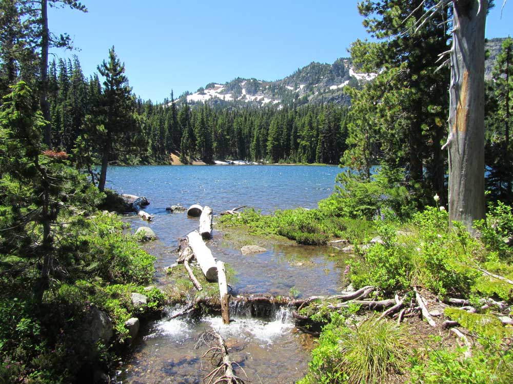
- Carl Lake features deep blue water and high-alpine scenery.
Backpacking into Carl Lake, in the Mount Jefferson Wilderness, hearkens back to recreating in the Central Oregon of old.
The lake is beautiful, its fish numerous and hungry, its shores pristine. Wildlife abounds under the snow-capped peaks and volcanic cinder cones that rim the lake. Often, there’s nary a person in sight. Not bad for a trailhead just an hour’s drive from downtown Redmond.
But Carl Lake, at an elevation of 5,600 feet, has its drawbacks.
And those obstacles to enjoyment are why so many people instead choose to avoid it, especially during the prime backpacking season of late June through August.
Overgrown trail with blown-down trees
The first obstacle to the peace and serenity of Carl Lake is the roughly 5-mile trail that begins at the Cabot Lake Trailhead, which is located about 14 miles of Highway 20, west of Sisters. A permit is required for all hiking in the area. Day trippers can pick one up at the trailhead while backpackers are required to purchase one online in advance.
The Cabot Lake Trail starts by winding its way through a 2003 burn scar that offers great views of a remnant lava flow and Mount Jefferson. The trail curves toward Cabot Lake in just 1.8 flat, fast miles. An unmarked spur trail on your right leads down to Cabot’s warm waters, which hold few fish but are deep enough for swimming and home to a bevy of what looked like rough-skinned newts. Good camp spots are lacking, however.
But if you skip Cabot Lake and keep on keeping on, the trail becomes downright menacing.
A dozen switchbacks of low-grade steepness give way to mile upon mile of downed trees spread across the trail. We counted 186 trunks laid across the path, while a hiker behind us counted 224. Imperfect math aside, there were innumerable trail obstacles that required maneuvering over, under or around while wearing unwieldy backpacks. Some obstacles required just a stoop or an off-balance jump, but other clumps of downed pines formed impassable walls requiring lengthy detours.
The lack of trail maintenance turns what should be a moderate hike into a much more exhausting one, sure to leave your shins scratched and scarred.
But the scratching has only just begun when you reach the final saddle below Carl Lake, where the trail passes three unnamed ponds and a new obstacle takes flight.
Attack from above and below and right between the eyes
Mosquitoes are the bane of plenty of midsummer hikes in the Cascades, and Carl Lake is no different. Melting snow and boggy areas — like those unnamed ponds — provide the perfect environment for larvae to flourish.
On the trail up, we ran into two other groups who were leaving their Carl Lake campsites a day early, rather than fend off another night of mosquitoes. At the lake, the bugs are incessant and only mildly dissuaded by the most poisonous repellants you can buy from the most disreputable dealer.
Currently, fires are allowed more than 100 feet from the lake, though that is subject to change. But stoking a small, smoky fire and sitting close to it may be the best way to enjoy a night at Carl Lake.
Still, don’t let the distractions keep you from enjoying the surroundings. Carl Lake is beautiful, its waters crystal clear and a vibrant blue hue. It’s home to some Cascades frogs, and ospreys and bald eagles visit often to fish its waters. Deer were disturbingly common — and fearless.
There are a few excellent campsites available, too. The trail arrives at Carl Lake’s southeast edge, where a steady wind can help keep the bugs away if you decide to bed down there. Prettier and roomier sites are possible by following the trail as it skirts the lake’s western flank.
Prettier still are the few tent-sized sites on the lake’s eastern flank, among the boulders and wildflowers, though no designated trail exists on that side. The mountain and sunset views are prettier from there, however.
Once you’ve made Carl Lake a base camp, options abound for side trails and further explanation.
It’s just 1.5 miles to join up with the Pacific Crest Trail to traverse the spectacular roller coaster ridgeline that leads to Mount Jefferson and beyond to the north, or Three Fingered Jack to the south.
Less than a quarter mile off the PCT, you can also poke around South Cinder Cone for expansive views and the opportunity to feel the volcanic history of the Cascades beneath your feet.
The easiest jaunt is a quarter-mile walk to charming Shirley Lake, much smaller than Carl but quiet and peaceful and a significant decline in flying flesh eaters. The Shirley Lake Trail departs from the west side of Carl, then continues up to the PCT and to South Cinder Cone.
Fishing for dinner
The Carl Lake rainbow trout are beautiful and good-sized, but can be picky.
They were most active during an afternoon hatch of green drake-like flies, and during that time could not be convinced to take anything else. But when that hatch died down, fish cruising the banks or holed up under rocks and ledges could be enticed with both stimulator and hopper patterns in the mornings and evenings.
The lake has a depth of more than 50 feet, so some lunkers are likely hiding down deep. But plenty were within reach of bank casts, and a nice shelf on the west side of the lake allows fly anglers to walk out and have plenty of room behind them for casting.
Because of the clear blue water, a thin leader is crucial. Lots of fish, especially in the afternoon sun, rose to the fly but then thought better of it before striking.
I blamed the leader, not the fisherman.
You can get to Carl Lake both through Camp Sherman and Highway 20. Perhaps the simplest route is to drive west past Sisters and the Metolius and turn right at the sign for Mt. Jefferson Wilderness Trailheads near milepost 88. The drive down paved Jack Lake Road for 4.5 miles, then left on gravel Road 1230 until it dead ends at Cabot Lake Trailhead.


