Nature on an even keel at Central Oregon’s Balancing Rock
Published 4:00 pm Thursday, May 18, 2023
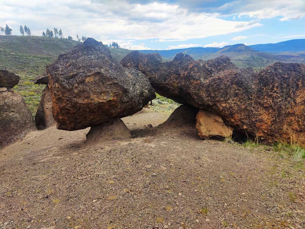
- A short stack of rock pillars at Metolius Balancing Rocks.
The captivating drive along the way to the Metolius Balancing Rocks makes the travel time seem irrelevant.
Just through the small town of Culver, you’ll see a yellow sea of farmland flowers before you enter The Cove Palisades State Park. Upon park entry, you get a breathtaking view of a canyon filled with a turquoise-blue reservoir connecting to the Crooked, Deschutes and Metolius rivers, jagged rocky cliffs, colorful bluffs and dense green forest. Narrow cable bridges in the park connect travelers to one scenic view after another.
The beginning of the quarter-mile Balancing Rock Trail overlooks a valley harboring the Metolius River arm with views of the surrounding mountains. Right away, the short dirt trail leads to the seemingly gravity-defying rocks balancing on the natural pillars. The pillars range in height, some as tall as trees, some as tall as people and many as tall as dogs.
A bit of history
First documenting this historical site in 1855, geologist Dr. John Strong Newberry noted the extraordinary rock formations during a railway survey.
Ancient volcanic eruptions and erosion created this geological marvel of balancing rock pillars called “hoodoos.” The pillar layers were formed by different eruptions millions of years ago. Softer unwelded layers of tuff formed at the base, while hardened welded layers of tuff formed the perched boulders on top. The lahars reached scorching temperatures during volcanic eruptions, fusing the ash and pumice into the hardened rocky tuff layer.
Over time, the softer sediment surrounding the pillars eroded by weathering. Uniquely, the balancing hardened tuff layers protected the soft pillared layers from erosion, similar to an umbrella from rain. These aspects caused the beautiful geological balancing of rocks that look like a human artistic creation. Some boulders perched on pillars look unstable, as if a gust of wind could blow them over, while others seemed sturdily welded together, frozen in eternity.
Unveiled by fire
Even though these rocks were documented in the mid-1800s, they weren’t well known until recently. To keep the site’s integrity, its location was left off maps to prevent damage from vandals and tourists. Occasionally hikers would stumble upon the site mentioning it by word of mouth. However, the location was no longer kept secret after a fire occurred in 2002.
The fire burned the surrounding vegetation, exposing the location and making it easily noticeable and accessible to the public. The site is listed on several online maps and set up to accommodate visits.
Though much vegetation has recovered, the surrounding area is still scarred from the devastating fire.
Perhaps the most significant balancing phenomenon at this site is nature’s resiliency when humanity allows it to heal.
Getting there: From Culver, head west on C Street and follow signs for Cove Palisades State Park. Stay on the winding Jordan Road through the park and beyond, including some 90 degree turns, then turn left on Graham Road, which becomes Montgomery Road. Stay left at the fork in the road and look for the small trailhead on the right.