Travel Time: Exploring Northern California’s secluded and splendid Lost Coast
Published 12:00 am Thursday, January 10, 2019
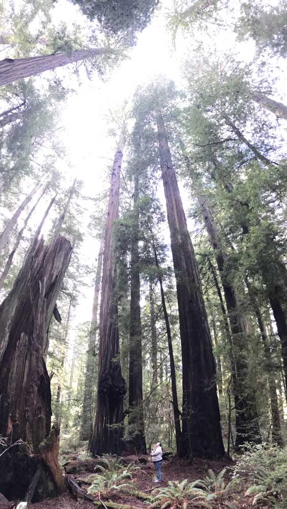
- Trees rise hundreds of feet in Humboldt Redwoods State Park. (Geoff Folsom/Spokesman photo)
For me, there’s no better time to visit the coast than in winter. The low temperatures are 10-to-20 degrees warmer than in Central Oregon and it’s a lot less crowded, both in towns and for my favorite activity, driving up the coast.
But after driving most of Highways 1 and 101 in California, Oregon and Washington, I was looking for a new challenge. And I more than found it in the “Lost Coast” in Northern California’s Humboldt County.
The stretch of coastline is reportedly the longest undeveloped coastal area in the continental United States. It’s steep cliffs and high seismic activity make it unsuitable for development. The area is located just north of where Highway 1 goes inland to merge with 101 (the highway department initially wanted to place the Pacific Coast Highway through the area but eventually gave up). The Lost Coast can be tough to reach, but well worth the trip.
Even in winter, the trip can be made in a long weekend from Redmond. The drive took about 8 ½ hours, with a couple stops. After a good breakfast, my wife, dog and I set out the next morning for the trip. We got off Highway 101 at tiny Fernbridge, which shares its name with a 108-year-old concrete arch bridge that crosses the Eel River. From there, it’s a short drive to beautiful Ferndale, a town of about 1,300 people known for its Victorian architecture.
In Ferndale, you follow signs for Petrolia, which lead you to the Mattole Road. You quickly start the climb up hills leading you out of town and see why everything is named for ferns.
After a short drive through a wooded area, you reach the crest of the hill, which offers the first stunning views of the Pacific coastline, looking northward to the spot where the Eel River goes into the sea. You learn to use primitive gravel pullouts to stop and view the scenery. There are no paved scenic viewpoints with restrooms and other amenities, but the solitude offered more than makes up for that.
The road slowly winds down toward the ocean, and, while there aren’t many tourists, you do have to look out for cows in the road and agricultural vehicles. We pulled off the road to let a pickup carrying large water tanks pass.
On the ocean side of the hills, trees become sparse, but that just allows you to see more of the water below.
About 20 miles in, you make one last dip to reach the short but spectacular oceanside drive. An imposing seastack lies just offshore as the road levels out.
Shortly afterward is a must stop — a monument to the Cape Mendocino Lighthouse, which stood nearby from 1868 to 1951. A plaque, one of the few interpretive signs on the drive, describes the lighthouse as standing at a 422-foot elevation, with a light that swept 30 miles out to sea.
The marker is at one of the rougher stretches on the beach, with waves crashing constantly onto the shore. You’ll know you’re at the lighthouse marker just before you reach the first of a couple one-lane bridges.
On the seven-mile coastal stretch, the waves crash on your right side, while hills tower on the left. That isn’t uncommon for the Pacific coast, but the serenity offered is. Instead of resort hotels, beach houses or crowded wayside parks, a single ranch home is all you see near the beach. Most of the passersby are farmers or county workers heading to the one park/campground with a restroom along the route, 36 miles in, well past the coastal drive.
As the flat stretch nears an end, you get a better view of the nearby King Range. The mountains are part of a BLM-owned conservation area that is only accessible by four-wheel drive vehicle (which we did not have).
After you go back up hill, you soon reach the picturesque little community of Petrolia, the site of the first oil well drilled in California. It has the only store I noticed after leaving Ferndale, as well as a post office and a cute school bell tower. A sign tells of a future historical museum, though it looks like it’s been there for a spell.
I would almost advise you to consider heading back to Ferndale at this point. The remaining route features a beautiful view of the Mattole Valley, but not much to see of the actual coast.
The road from Ferndale to the coast featured numerous potholes and steep hills (my Honda even bottomed out a couple times). But the drive from Petrolia on is even more treacherous.
You head up a hill that seems to have no peak, twisting around hairpin turns while trying to keep pushing the gas pedal to build up speed to climb the steep hills (and this was on a nice day). The potholes get harder to avoid and there are several spots with no pavement, where the road is presumably being repaired after getting too much damage. One area where the side of the road had, apparently, fallen off was marked by orange cones.
But after driving 60 miles and three hours from Ferndale, the payoff comes. The road narrows but becomes much more smooth. The forest goes from a wooded area you might see anywhere along the West Coast to a mesmerizing forest out of a fairy tale. You’ve entered Humboldt Redwoods State Park, which features 17,000 acres of old-growth coastal redwoods.
Even on a sunny day, the drive was completely shaded through a beautiful area lush with ferns. The trip takes you through the 7,000-acre Rockefeller Forest, where you can take an easy hike. The forest features the 362-foot-tall Rockefeller Tree.
After going six miles through the forest, you arrive back at Highway 101. If you still have energy left, you can go south and take another mountain road out to Shelter Cove, a fishing village on another stretch of the Lost Coast. Or you can take a ride on the Avenue of the Giants, which runs through the redwoods along 101.
If you’ve got a lot of time and want to see parts of the area inaccessible by car, you can even backpack the whole way on the 25-mile Lost Coast Trail.
Dining
We decided to grab a bite to eat just up the road at the Loleta Cheese Factory. The building in the small town of Loleta offers a variety of free cheese samples that puts Tillamook to shame. My wife and I went to the grilled cheese bar and shared the delicious “Strawberry Blonde” (sweet and savory) and “Bay Area Brisket” (meat and cheese!) sandwiches. Both were delicious after a long drive.
We didn’t want to drive on an empty stomach, so we started the day with omelets at the Cafe Nooner in Eureka. Both restaurants have been featured on the Food Network’s “Diners, Drive-ins and Dives.” While the show’s host, Guy Fieri, is as cheesy as the Loleta sandwiches, we’ve never gone wrong with a restaurant that’s been on “Triple D.”
One of the neat features of the area is that Fieri is a native of Ferndale, so local restaurants have been featured more often than a typical remote, relatively low-populated region. You can find the restaurants on the “TV Food Maps” app, though double-check because some appear to have moved on to the Flavortown in the sky.
Where to stay
While Ferndale has some beautiful historic hotels, they were a bit out of our price range, so we stayed 20 miles away in Eureka. The downtown has a nice bayfront walk, as well as numerous shops to browse. We capped our trip with dinner at the Lost Coast Brewery downtown.
The brewery has two locations in Eureka, one for dining and another where you can see the beer made. Since there aren’t a lot of souvenir shops on the Lost Coast scenic drive, this might be your best bet to get mementos with the Lost Coast name on them.
Getting there
Going nearly anywhere from Central Oregon is a challenge this time of year. The most direct route we found was to take Highway 97 south to Highway 138 near Crater Lake, then make your way over to Grants Pass, where you get on Highway 199 to Crescent City. That allows you to take a nice 85-mile drive along the coast. One caution on this route is that a stretch of Highway 138 was a sheet of ice, despite it being clear outside.
The roads were better on the way back, where we took Highway 299 from Arcata to Redding. This is a beautiful route through mountains and national forests and along the Trinity River, but the numerous passes make it seem to take forever. The 139-mile drive is much longer than the 50-to-60 mile drives you might be used to going between Highway 101 and Interstate 5 in Oregon.
Though there was snow and rain, the drive north on I-5 and then along Highway 97 from Weed was much easier than going by Crater Lake.
Or you could just head up the coast into Oregon for a while before you cut over. In this part of the country, you’re bound to find a scenic route.
— Reporter: 541-548-2186, gfolsom@redmondspokesman.com